![“Our Heads Are Round so our Thoughts Can Change Direction” [Francis Picabia]](https://foodforthought.barthel.eu/wp-content/uploads/2021/10/Picabia-Francis-Round-Heads.jpg)
![]() Braunschweig, March 2015 Thanks to unforseen circumstances, the last days forced us to reconsider the entire development and timeline for the CheckIn.com project. So far, it was planned to be ready with development by February, Mid March and prepare for rollout at Routes Europe in April in Aberdeen. We have now decided to cancel that event overall, a hard and unhappy decision! But. Especially to digg out the U.K. statistical basics caused us major delays, getting incompatible figures from the same source, not just self-researched but also from the ONS (U.K. Office of National Statistics). We learned they mostly only cover England & Wales, neither Scotland or Northern Ireland. Sure with exceptions, which, if you’re kept unaware, simply cannot compute!
Braunschweig, March 2015 Thanks to unforseen circumstances, the last days forced us to reconsider the entire development and timeline for the CheckIn.com project. So far, it was planned to be ready with development by February, Mid March and prepare for rollout at Routes Europe in April in Aberdeen. We have now decided to cancel that event overall, a hard and unhappy decision! But. Especially to digg out the U.K. statistical basics caused us major delays, getting incompatible figures from the same source, not just self-researched but also from the ONS (U.K. Office of National Statistics). We learned they mostly only cover England & Wales, neither Scotland or Northern Ireland. Sure with exceptions, which, if you’re kept unaware, simply cannot compute!

Scotland does not cover the Local Administrative Units Level 2 of Eurostat, they consider those useless and calculate “something” only on demand. Ireland came last (by end of February) and again with non-standard numbers we now have to “make compatible”. To qualify the difficulty to get the basics for the U.K.: Covering geographic Europe, including Balkan countries and other non-EU countries, the U.K. made it a multitude more difficult for us to get some useful information.
 Another issue is drive times, where we have to deal with the fact that “unique administrative places” are not being found either in Google, nor by other on- and offline mapping tools. Often, road data is missing completely, making it impossible to calculate any drive times. Especially going east that caused us quite some headaches (and night shifts). So now finally, though with already some delay, we have everything covered. But we recognize that “mapping” is a major fuzziness, if we go with existing technologies – we should buy into commercial collections of administrative borders, though which also don’t completely match with the data we are having.
 So January 1st, we started the crowdfunding on Indiegogo, hopeful to get enough interest to finance the necessary development. Generating interest and funds mostly from unexpected sources, by early February our hopes shattered, our friends leaving us out alone in the cold. Very little buzz, not even supportive comments to us, even from our close friends, ad sure no orders for Isochrones. A real nice classic barrel burst. Simply dead silence. Not a bad thing, in fact it confirmed our initial approach to go in a step-by-step process, fund as we can, do what we can, but not to rely on investors (requiring fast return-of-investment, having their own agendas) and do “ourselves”.
 Then came the shock. Within days, Jürgen went into sickleave, undergoing a major surgery Feb 27th, taken completely out of the loop for the better part of 14 days and being still hospitalized (4th week), depriving us from the most knowledgable and networked expert in our team. He is well now, still recovering, still hospitalized. The tumors identified turned out a haemangiome (as “known” since 2002) and a benign neuroendokrineous one.
So after recovering from the major surgery, he shall be almost as new (minus half a pancreas, the spleen and a bit of his liver and plus a possible diabetes). Celebrating his 50th birthday recently, he feels “old now” thanks to the fact that for the remainder of life he got to carry a pillbox and injection pens with him to cover for the lost half pancreas.
But the main setback is the delayed recovery; instead of the expected 10-14 days we now talk more about min. 4-5 weeks that we lost his support for. With all that baggage, we were faced with a tough decision. Do we keep up the plan to go live at Routes Europe? Or do we have to postpone? Especially with the desinterest showed for our crowdfunding, the missing funds to secure external development for the remaining solutions, problems with providing a solution for maps now and Jürgen’s missing help, we decided against Routes Europe and for a delay.
 Having the drive time calculations completeted for Europe, we will now start to work on North America already. With the custom tool received by Richard Marsden, we are hopeful to get that covered maybe in time for World Routes, for sure until next Routes Americas. Having the solution for the most complex of our algorithms (thanks Ori) we are also pre-computing the impact values for each airport from the municipality-view. As in most cases the passengers have not just one airport, but optional others to choose from. Depending on the size of the airport, the drive time to get there as well as the flight services offered. But yes, it is quite a bit work and even computerized a real lengthy task to apply these algorithms to all the airport-municipality pairs…
For the maps, we now need to check “low cost solutions”, looking into Google (no “freebees” as Bing), offline mapping tools and maybe Open Street Maps. We assume this takes another 4-6 weeks minimum and we might have to use “offline mapping” as a work-around, with map-creation taking some additional “non-automated” time.
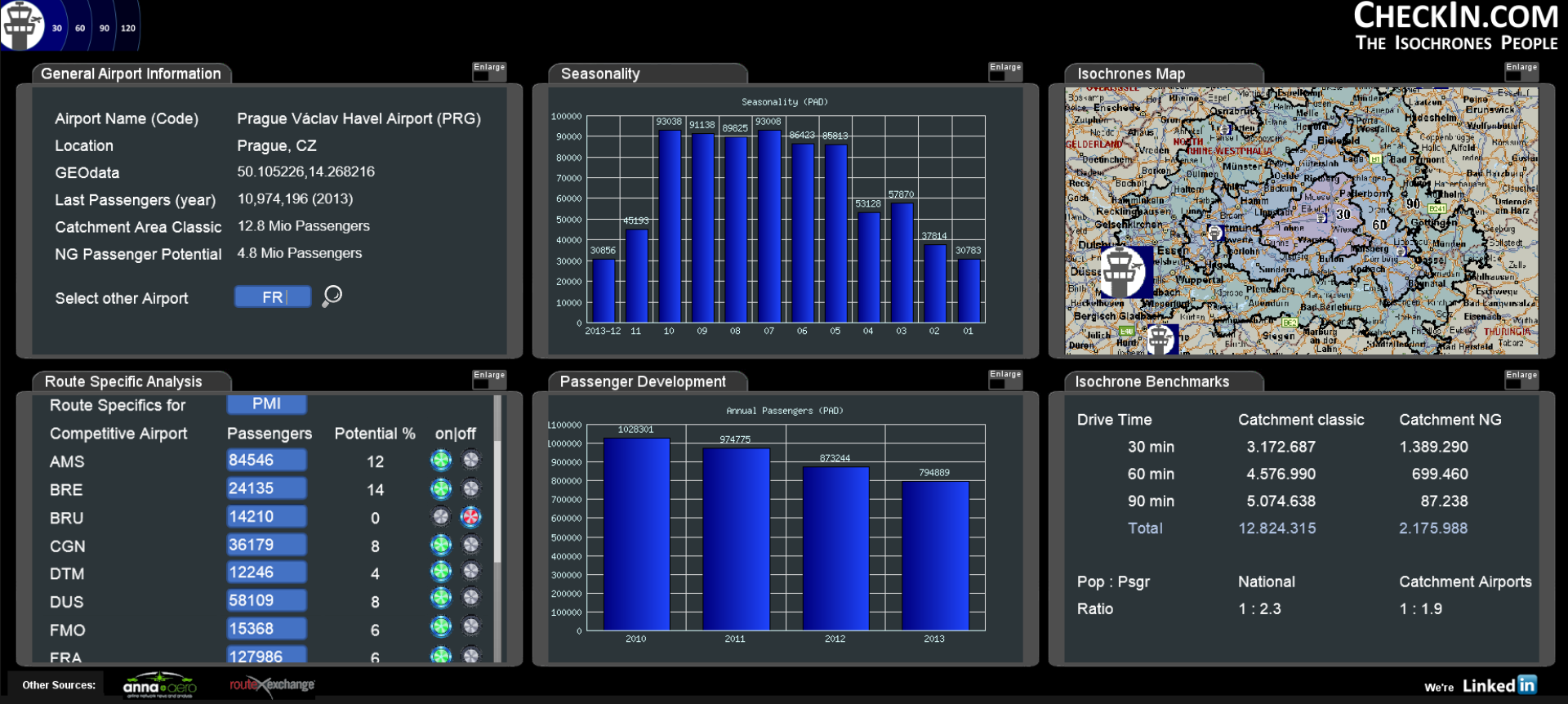
Without the admin borders, we think about a solution to quantify the passenger potential by municipality, thus making “hot spots” visible. Also something to keep us busy, but the benefits of not needing the municipal borders in the display justifying for that. We also got the funding to do a real good prototype of the dashboard, but it takes time to write the necessary software requirements specification.
 Then we have to find a web-agency that can do it (the famous needle in the haystack problem). But without map(s), the dashboard is incomplete, so there must be some “placeholder” while we create the map(s). All those tasks we now have to do on our own finally summed up to the painful decision to reschedule the development plans and skip Routes. Which was especially hard on Jürgen to convince, who is a great fan of that event. We do hope you can understand the reasoning behind our decision and appreciate your feedback – supportive, critical, honest. And if you have ideas how to speed up our agenda, if you have reference to a real good web-agency, you are very welcome! Just a little bit
but as usual: comments welcome!